

StellaSpark Nexus
StellaSpark Nexus is a real-time digital twin platform for monitoring and simulating the natural and built environment across sectors such as urban planning, public safety, construction, water management, energy, mobility, telecommunications, forestry, and environmental...
Cost / License
- Subscription
- Proprietary
Platforms
- Online
- Software as a Service (SaaS)

Features
- Data analytics
- Data visualization
- Dashboard
Tags
- environmental-monitoring
- sensor-monitoring
- Compliance
- data-integration
- physics-simulation
- scenario-modelling
- digital-twin
StellaSpark Nexus News & Activities
Recent activities
 stellaspark added StellaSpark Nexus as alternative to Palantir Foundry, ArcGIS, CartoDB and MangoMap
- stellaspark updated StellaSpark Nexus
- stellaspark liked StellaSpark Nexus
- stellaspark added StellaSpark Nexus
- POX updated StellaSpark Nexus
 stellaspark added StellaSpark Nexus as alternative to Tableau, Microsoft Power BI, Apache Superset and Spotfire
StellaSpark Nexus information
Developed by
StellaSparkLicensing
Proprietary and Commercial product.Pricing
Subscription that costs $0 per month.Alternatives
4 alternatives listedSupported Languages
- English
- Dutch
- French
- Spanish
- Italian
- Chinese
- Arabic


What is StellaSpark Nexus?
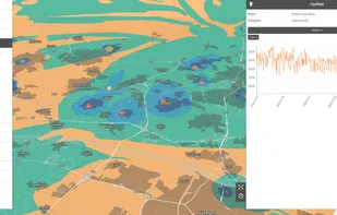
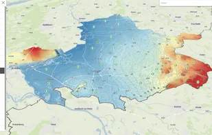
StellaSpark Nexus is a real-time digital twin platform for monitoring and simulating the natural and built environment across sectors such as urban planning, public safety, construction, water management, energy, mobility, telecommunications, forestry, and environmental management. It enables governments, NGOs, utilities, contractors, engineers, and technical consultants to automate environmental compliance, identify risks and opportunities, quantify the impact of infrastructure projects or environmental change, track progress toward policy objectives and save time by seamlessly sharing data with partner organizations and public stakeholders.
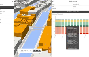
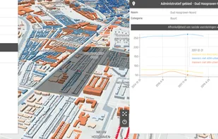
The platform integrates live data from virtually any source - including IoT sensors, geospatial datasets, photos, and web-scraped feeds - and transforms it into performant, interactive 2D and 3D maps and time-series charts that are always up-to-date. Users can simulate scenarios, calculate metrics or continously generate operational forecasts by deploying physics-based models, machine learning algorithms, or their own custom scripts directly within the digital twin. Secure APIs and open data portal functionality make it easy to share data and insights with partners, public stakeholders, and external tools.
Features:
- Link map features with timeseries and photos
- Bring raster and vector data to life in 2D or 3D maps
- Connect sensor measurements to spatial objects or regions and display results in interactive charts
- Integrate data from virtually any spatial format and protocol (KML, GML, GeoJSON, Geotiff, WMTS, WFS, HDF, NetCDF, Shapefile), photos, time series from IoT devices and sensors such as JSON, CSV, XML or semi-structured data from websites
- Maps and charts update continuously, ensuring the digital twin reflects the current state of assets and environments without requiring manual re-imports or refreshes
- Operational forecasting and scenario analysis
- Browser-based viewer runs on desktop, tablet, and mobile without additional software installation
- Use Nexus as an open data portal, or securily connect Nexus to external applications through REST APIs or direct database connections for programmatic access