The Ultimate Mountain Toolkit
Outmap is made for explorers who want clarity and confidence outdoors. Whether you're
skiing a new line, planning a hut trip, or just looking for the safest way down, Outmap
puts all the tools you need in one place. Plan on desktop, take your phone, and sync
effortlessly between the two.
🏔 See the terrain in 3D
Visualise ridges, valleys, and slopes just as they appear in real life, with contour
lines and high-resolution hillshading when you need the detail.
? Read the slope before you commit
Slope angle, aspect shading, elevation bands and flat-area highlighting, as map layers
you can turn on and combine. Build your own custom terrain layer if the defaults aren't
the ones you plan by.
?? Avalanche information, built in
Canadian and US avalanche bulletins integrated directly into the map, on every Outmap
subscription.
🛰 Switch the imagery to suit the job
Multiple satellite sources: Maxar for high resolution, Mapbox for balanced clarity and
performance, NAIP for US aerial, and winter imagery for snow-covered terrain.
📴 Stay connected, even offline
Download areas ahead of time and explore with confidence, even without a signal.
🎿 Explore resorts too
Outmap isn't just for the backcountry, we've got all your favourite resort runs mapped
as well.
📖 Guidebooks written for the app
Four published guidebooks, 131 routes: Cascade River ski loops, Mount Rainier ski
descents, Great Canadian ski traverses, and Mount Washington.
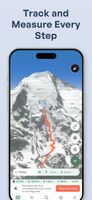
? Track every step
Log your hikes, rides, or ski tours in real time, whether the app is open or running
quietly in the background. Save your lines and your battery life.
?? Keep it all in sync
Your library of saved routes and GPX files is backed up to the cloud and available on
every device.
🔄 Import and export with ease
GPX, KML, KMZ and GeoJSON. Import routes from friends or guidebooks, or share your own
with just one tap.
Outmap is designed for backcountry enthusiasts and professionals who seek clarity and
confidence while outdoors. Whatever you're doing in the backcountry, the right tools
make all the difference.







 Runplanner added Outmap as alternative to Runplanner
 invs added Outmap as alternative to onX Backcountry


 Felix Gourdeau