Know exactly how many calories you'll burn on every mile of your trip — based on the real terrain, your pack weight, and your body. MTNMetrics is precision nutrition planning for backcountry hikers.
Stop guessing how much food to pack. Whether it's a weekend overnighter or a multi-week thru-hike, MTNMetrics calculates your day-by-day calorie and macro needs from published metabolic research — not generic per-mile math.
HOW IT WORKS
Draw your route on a high-fidelity 3D terrain map or import a GPX file from your favorite planning app. MTNMetrics reads every segment — grade, elevation gain, elevation loss — and combines it with your body and pack weight to work out exactly what the trip will cost you in calories.
Then build a meal pack to match: browse the food catalog, filter for your diet, and watch calories, protein, fat, carbs, and pack weight add up as you go.
KEY FEATURES
? Terrain-Aware Calories
Per-segment burn from the LCDA equation (Looney et al. 2022). Not a generic calories-per-mile guess.
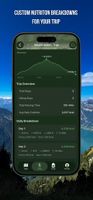
? Day-by-Day Nutrition
Day 1 might need 4,200 cal. Day 2, 5,100. Plan each day, not an average.
? 680,000+ Foods
Backcountry meal brands, grocery items, and generic staples — with photos and nutrition details. Scan any barcode to add food straight from the package.
? Meal Pack Builder
Categories, dietary filters (vegan, gluten-free, dairy-free), and real-time calorie and weight tracking against your trip targets.
? Route Authoring & Editing
Snap-to-trail drawing, waypoints, GPX import. Drag a waypoint to reshape the line, or tap mid-route to drop in a new point.
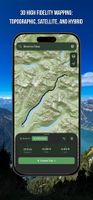
? 3D Trail Maps
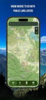
Contours, hillshade, satellite, and day/night themes. Overlay active wildfire perimeters, slope-angle shading, and public lands. Your saved trips draw right on the map — tap any route to reopen it.
? Built Around You
Weight, height, age, sex, and body fat tune every number to you.
BUILT ON SCIENCE
The LCDA equation from peer-reviewed metabolic research, Tobler's hiking function, and Santee grade adjustments — working quietly behind a number you can trust.
PLAN SMARTER, PACK LIGHTER
Every ounce rides on your back. Pack exactly the right amount of food — no bonking below the pass, no hauling dead weight down the other side.
? Terms of Use:
https://www.mymtnmetrics.com/terms
? Feedback
Have an issue or want to submit a feature request? Please contact us at contact@mymtnmetrics.com.









 Amanda-Harger added MTNMetrics: Trail Nutrition as alternative to AllTrails, Outdooractive, onX Backcountry and Gaia GPS
 MTNMetrics LLC

