Apps with 'Mapping' feature Page 6 of 9

All apps in Apps with 'Mapping' feature category. Use the filters below to narrow down your search. 
Copy a direct link to this comment to your clipboard
  1. HealthMap icon
     1 like

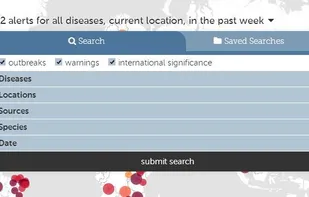
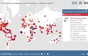
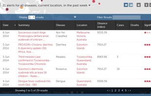
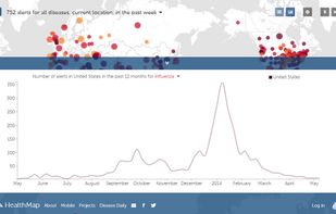
    HealthMap, a team of researchers, epidemiologists and software developers at Boston Children's Hospital founded in 2006, is an established global leader in utilizing online informal sources for disease outbreak monitoring and real-time surveillance of emerging public health...

    Cost / License

    • Free
    • Proprietary

    Platforms

    • Online
    HealthMap screenshot 1
    HealthMap screenshot 1
    HealthMap screenshot 2
    +1
    HealthMap screenshot 3
  2. GlobeInfos icon
     1 like

    GlobeInfos is a mobile tracking service : it offers geolocation of vessels, boats, cars, trucks through INMARSAT or IRIDIUM satellite networks and allow the possibility to visualize them online on your favorite web browser.

    Cost / License

    • Paid
    • Proprietary

    Platforms

    • Online
    Globeinfos Homepage
    Details informations
    The main tracking page
    3 alternatives
  3. GM Forge icon
     1 like

    GM Forge is a Standalone Virtual Tabletop and is a sandbox for GMs. Friends can join through web browsers for free once the GM purchases a copy.

    Cost / License

    • Paid
    • Proprietary

    Application type

    Platforms

    • Windows
    • Steam
    GM Forge screenshot 1
    GM Forge screenshot 1
    GM Forge screenshot 2
    +3
    GM Forge screenshot 3
    20 alternatives
  4. MapViewer icon
     Like

    MapViewer is an affordable mapping and spatial analysis tool that allows you to easily produce publication-quality thematic maps. Precisely display your data distribution with the most intuitive functions and features.

    Cost / License

    • Paid
    • Proprietary

    Application type

    Platforms

    • Windows
    6 alternatives
  5. indiemapper icon
     2 likes

    This is an online mapping site that "helps you make static, thematic maps from geographic data by bringing the best of traditional cartographic design to internet map-making." Sponsored by Axis Maps, LLC.

    Cost / License

    • Free Personal
    • Proprietary

    Application type

    Alerts

    • Discontinued

    Platforms

    • Online
    Landing Page
    Initial screen
    11 alternatives
  6. MapLarge icon
     1 like

    Beautiful, User Friendly online mapping software that scales to big data.

    The MapLarge API enables user-driven, low latency, interactive visual exploration and analysis of very large geospatial and non-geospatial data collections to recognize patterns and identify anomalies. Use.

    Cost / License

    • Freemium
    • Proprietary

    Application types

    Platforms

    • Windows
    • Linux
    • Online
    MapLarge API
    MapLarge screenshot 1
    MapLarge screenshot 2
    27 alternatives
  7. Search, filter and map locations by travel time rather than distance with this API. When added to a location search engine it can search and display results by time and create travel time maps for users. In-depth data analysis also available.

    Cost / License

    • Paid
    • Proprietary

    Platforms

    • Mac
    • Windows
    • Linux
    • Online
    • iPhone
    • Chrome OS
    • iPad
    • Apple TV
    Mapping travel time areas in London
    23 alternatives
  8. Patchwork 3D Enterprise makes it easy to use real-time photorealistic rendering to shorten design cycles, base your communication, marketing and sales through: VR, CAVE, Powerwall, AR, web configurator, collaborative tools, mobile, online/offline.

    Cost / License

    • Paid
    • Proprietary

    Application type

    Platforms

    • Windows
    Patchwork 3D Enterprise screenshot 1
    Patchwork 3D Enterprise screenshot 1
    15 alternatives
  9. SuperGIS icon
     8 likes

    Supergeo Technologies Inc. is global leading GIS software & total solution provider. With series GIS products covering from desktop, mobile, server to developer SDK, SuperGIS has been utilized more than 100 different countries.

    Cost / License

    • Paid
    • Proprietary

    Application types

    Platforms

    • Windows
    • iPhone
    • iPad
    SuperGIS Desktop with  rich GIS analyze tools
    SuperGIS Server provides enterprise GIS online services
    SuperGIS Server provides enterprise GIS online services
    +3
    SuperGIS Desktop with  rich GIS analyze tools
    33 alternatives
  10. Peerdom icon
     5 likes

    Peerdom is a clean, simple tool for mapping roles and responsibilities within an organisation. Enable your entire team to make confident, autonomous decisions, and stimulate your organisation's agility and resilience.

    Cost / License

    • Paid
    • Proprietary

    Platforms

    • Online
    Peerdom screenshot 1
    4 alternatives
  11. mamap.io icon
     1 like

    Easily create and embed a customizable, interactive map with markers, images and search functionality in just a few minutes. Enhance and customize your user experience without using ugly iframes.

    Cost / License

    • Paid
    • Proprietary

    Application type

    Platforms

    • Online
    • Software as a Service (SaaS)
    Homepage
    Maps management
    Maps creation and editing
    11 alternatives
  12. Geocode Earth provide quality Address Autocomplete, Reverse Geocoding & Place Geocoding solutions to small-to-medium sized businesses.

    Cost / License

    • Paid
    • Open Source (MIT)

    Platforms

    • Online
    • Ruby
    • Python
    • JavaScript
    • cURL
    • PHP
    • Ruby on Rails
    Geocode Earth screenshot 1
    10 alternatives
  13. Spatial Feature Server by MapET is an ESRI Geoservices REST Implementation and works with all ESRI Rest API's. The source of published data is the spatial extension of the major RDBMS, such Oracle, Microsoft SQLServer, MySQL, PostgreSQL.

    Cost / License

    • Paid
    • Proprietary

    Application types

    Platforms

    • Windows
    35 alternatives
  14. Pre-configured VM servers: map servers, driving directions, geocoding and reverse-geocoding. Ready for integration and deployment.

    Cost / License

    • Paid
    • Open Source

    Platforms

    • Windows
    • Linux
    • Self-Hosted
    Tile server running on a VM serving maps
    Step by step routing and directions (address or GPS coordinates)
    Output of geocoding and reverse geocoding from API query
    9 alternatives
  15. Spotzi icon
     1 like

    Spotzi is an easy-to-use online geomarketing platform you can try for FREE. Spotzi has a short learning curve, so you don't have to be a data scientist to work with Spotzi. Our main goal is to find your best-fit customers in just a few clicks.

    Cost / License

    • Freemium
    • Proprietary

    Application type

    Platforms

    • Mac
    • Windows
    • Linux
    • Online
    • Android
    • iPhone
    • Android Tablet
    • Windows Phone
    • iPad
    Select one of the geomarketing tools to visualize the areas with your best-fit customers.
    Create a drivetime radius map in just a few clicks.
    Gain more insights into the customers within a drivetime radius.
    +1
    Analyze consumer profiles and know where to reach them.
    37 alternatives
  16. ProAlign icon
     1 like

    ProAlign provides an integrated suite of web-based and desktop territory analysis and mapping software.

    Cost / License

    • Paid
    • Proprietary

    Application type

    Platforms

    • Windows
    • Online
    ProAlign screenshot 1
    5 alternatives
  17. The Gmap Uploader is a service that allows you to upload any map or image you want into the Google Maps interface. From there, you can use the Google Maps API to put markers, info windows (bubbles), and polylines (routes) on your map. Visit the Gmap Uploader wiki for more info.

    Cost / License

    • Free
    • Proprietary

    Platforms

    • Online
  18. Mapknitter is a free and open source webapp that can be used for referencing and producing maps.

    Cost / License

    • Free
    • Open Source

    Platforms

    • Online
  19. Quick and easy Custom Maps for Mobile, Tablet, and Computers - Use a list of addresses, coordinates, or other location data to quickly & easily make maps. Basic and advanced maps to produce custom filters.

    Cost / License

    • Freemium
    • Proprietary

    Platforms

    • Online
    24 alternatives
  20. LeaseMatrix is a user-friendly commercial lease analysis software developed for commercial real estate tenants, landlords, investors and brokers. The application is 100% web-based and allows anyone to easily analyze and compare lease proposals from any computer or tablet device.

    Cost / License

    • Paid
    • Proprietary

    Platforms

    • Online
    LeaseMatrix screenshot 1
    LeaseMatrix screenshot 1
    3 alternatives
  21. Map Pad icon
     Like

    Map Pad is an application that turns your maps into notepads. It behaves like a painting application, allowing you to use a variety of brushes to write letters, and draw lines or illustrations on your maps.

    Cost / License

    • Free
    • Proprietary

    Application type

    Alerts

    • Discontinued

    Platforms

    • iPhone
    • iPad
    Map Pad screenshot 1
    Map Pad screenshot 2
    Map Pad screenshot 3
    20 alternatives
  22. GeoKettle icon
     Like

    GeoKettle is a powerful, metadata-driven Spatial ETL tool dedicated to the integration of different spatial data sources for building and updating geospatial data warehouses. GeoKettle enables the Extraction of data from data sources, the Transformation of data in order to...

    Cost / License

    • Free
    • Open Source

    Application type

    Platforms

    • Mac
    • Windows
    • Linux
    1 alternatives