Map Services Page 12 of 14

All apps in Map Services category. Use the filters below to narrow down your search. 

Popular filters:

Copy a direct link to this comment to your clipboard
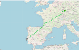
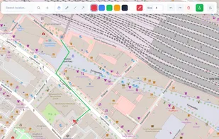
  1. Value-based routing over API for Cars & Trucks uses cost factors to calculate routes and not minimizing distances; it uses a proprietary artificial intelligence model to estimate ETAs. Considering toll and multiple mandatory driving breaks. Available for Europe.

    Cost / License

    • Paid
    • Proprietary

    Platforms

    • Software as a Service (SaaS)
    Value-based Routing screenshot 1
    9 alternatives
  2. SkyLines icon
     Like

    Internet platform for flight sharing: Flight Database; Live Tracking; Flight Analysis; Task Planning; Competitions; Achievements; Social Network.

    Cost / License

    • Paid
    • Proprietary

    Application type

    Platforms

    • Online
    SkyLines screenshot 1
    SkyLines screenshot 1
    SkyLines screenshot 2
    +1
    SkyLines screenshot 3
    3 alternatives
  3. Travic icon
     Like

    Transit map visualizer showing movement transit vehicles using data published by transit agencies and operators from all over the world. Wherever real-time data is available it is also included in the visualization; otherwise the movements are based on static schedule data.

    Cost / License

    • Free
    • Proprietary

    Application type

    Platforms

    • Online
  4. The problem with sending a screenshot of a map is that it is just a flat image. If the other person doesn't recognise the street, they are stuck. Draw On A Map fixes this by sharing a real map so people can figure out where they are now.

    Cost / License

    • Free
    • Proprietary

    Application type

    Platforms

    • Online
    Instructions from train station
    5 alternatives
  5. The Clio icon
     Like

    Named after the ancient Greek muse of history, Clio puts history at your fingertips. With your permission, Clio picks up your present location and guides you to landmarks, museums, and historic sites. It also acts as a virtual time machine, allowing a user to see images and...

    Cost / License

    • Free
    • Proprietary

    Application types

    Platforms

    • iPhone
    • iPad
    The Clio screenshot 1
    The Clio screenshot 1
    The Clio screenshot 2
    +3
    The Clio screenshot 3
    7 alternatives
  6. Geoadmin icon
     Like

    geo.admin.ch ist die Geoinformationsplattform der Schweizerischen Eidgenossenschaft innerhalb der Bundesverwaltung.

    Cost / License

    • Free
    • Open Source

    Application type

    Platforms

    • Online
    • Self-Hosted
    3D Map
    Sattelite
    color map
    10 alternatives
  7. Tarmacs icon
     Like

    Tarmacs is the route planner app dedicated for road and gravel bikers. It suggests best tarmac and gravel roads thanks to synergy of social sharing. Currently covers Europe.

    Cost / License

    • Free
    • Proprietary

    Platforms

    • Online
    • Software as a Service (SaaS)
    Tarmacs: Route planning, with POIs and climb markers
    Tarmacs: The route with weather forecast on track.
    Tarmacs: Export to bike computer, including important waypoint notifications, like cafes, water, attractions and dangers.
    7 alternatives
  8. Superlocal is the AI Travel Map & Tracker that finds the best places for you — then auto-logs every visit so you can relive the journey. Think Google Maps + Foursquare + Swarm + Fog of World, super-charged by personalization.

    Cost / License

    • Freemium
    • Proprietary

    Platforms

    • iPhone
    • Online
    Superlocal screenshot 1
    Superlocal screenshot 1
    Superlocal screenshot 2
    +3
    Superlocal screenshot 3
    10 alternatives
  9. MapPrints icon
     Like

    MapPrints allows anyone of any skill to design their own amazing art and home decor based on maps of their favorite places. Pick any place on earth. Design your own stunning home decor.

    Cost / License

    • Paid
    • Proprietary

    Application type

    Platforms

    • Online
    MapPrints screenshot 1
    MapPrints screenshot 1
    MapPrints screenshot 2
    +2
    MapPrints screenshot 3
    7 alternatives
  10. Tasmap icon
     Like

    Tasmap is a clean interface to create your own maps. Design your own color scheme, add content, and combine them into a beautiful map app.

    Cost / License

    • Freemium
    • Proprietary

    Application type

    Platforms

    • Online
    Tasmap screenshot 1
    Tasmap screenshot 1
    Tasmap screenshot 2
    +5
    Tasmap screenshot 3
    1 alternatives
  11. bikerouter.de is a web-based route planner for all kinds of bicycles (trekking, road bike, gravel bike, mountainbike, and many more) with specialized and adjustable routing profiles.

    Cost / License

    • Free
    • Proprietary (MIT)

    Application type

    Platforms

    • Online
    bikerouter.de screenshot 1
    bikerouter.de screenshot 1
    1 alternatives
  12. 1940s NYC icon
     Like

    Between 1939 and 1941, the Works Progress Administration collaborated with the New York City Tax Department to collect photographs of most buildings in the five boroughs of New York City. In 2018, the NYC Municipal Archives completed the digitization and tagging of these photos.

    Cost / License

    • Free
    • Proprietary

    Application type

    Platforms

    • Online
    1940s NYC screenshot 1
    1940s NYC screenshot 1
    1940s NYC screenshot 2
    3 alternatives
  13. Find articles from wikipedia/wikivoyage near given geographic location to be displayed in an interactive map through a generated kmz file - GitHub - k3b/AndroidGeo2ArticlesMap: Find articles from wikipedia/wikivoyage near given geographic location to be displayed in an...

    Cost / License

    Platforms

    • Android
    • Android Tablet
    8 alternatives
  14. Outmap icon
     Like

    Explore the backcountry with the ultimate mountain toolkit. Outmap combines detailed 3D maps, offline access, intuitive library management, and advanced safety tools.

    Cost / License

    • Freemium
    • Proprietary

    Platforms

    • Android
    • iPhone
    • iPad
    • Android Tablet
    The Ultimate Mountain Toolkit
    See the Terrain in 3D
    Track and Measure Every Step
    +3
    Plan With Precision
    1 alternatives
  15. Open Historical Map (OHM) is a site that uses the OpenStreetMap (OSM) software stack as a foundation for building an open source, user-editable historical map. This project's goal is to create the world's most universal, detailed, and...

    Cost / License

    • Free
    • Open Source

    Application type

    Platforms

    • Online
    OpenHistoricalMap screenshot 1
    3 alternatives
  16. Modern Map Art takes your favorite cities, mountains, and places and turns them into beautiful works of art. Use the custom editor to create topo maps, street maps, and building maps if your favorite place.

    Cost / License

    • Paid
    • Proprietary

    Application type

    Platforms

    • Online
    Modern Map Art screenshot 1
    Modern Map Art screenshot 1
    7 alternatives
  17. Umkreisel icon
     Like

    Customize your own map like never before: Combine background maps with real-time layers like gas prices, weather, traffic, light pollution, and 100+ location filters. Plan trips, find essentials, and explore smarter—all in one app.

    Cost / License

    • Freemium
    • Proprietary

    Application type

    Platforms

    • iPhone
    • iPad
    • Android
    Umkreisel screenshot 1
    Umkreisel screenshot 1
    Umkreisel screenshot 2
    +5
    Umkreisel screenshot 3
    7 alternatives
  18. TrueSize.net is a free interactive map tool that lets you compare the actual land area of countries, states and historical territories — correcting for map-projection distortions and enabling side-by-side size comparisons.

    Cost / License

    • Free
    • Proprietary

    Application type

    Platforms

    • Online
    Welcome screen
    TrueSize.net screenshot 1
    TrueSize.net screenshot 2
    +2
    TrueSize.net screenshot 3
    1 alternatives